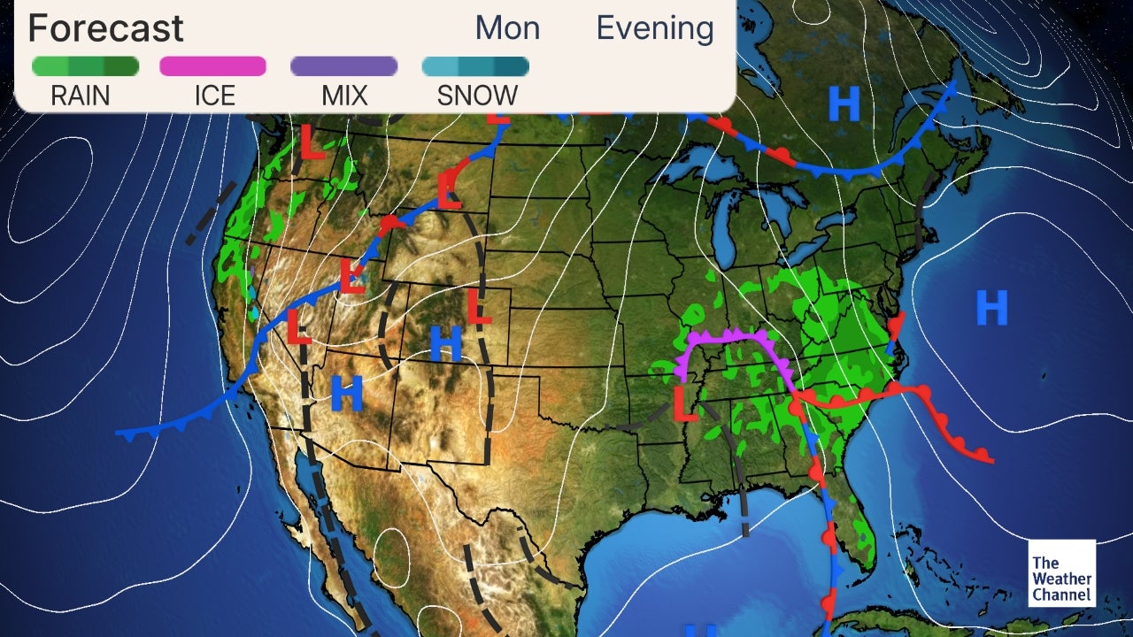
Surface high pressure passing around the Mason Dixon Line allows for a delightful start to the weekend as sunshine will be abundant, with comfortable highs in the upper 60s to mid 70s. Although a weak upper level disturbance provides the chance of a few sprinkle today, mainly over the higher terrain north. You will not even have to worry about packing that rain jacket if you plan on heading into the woods and I would definitely not cancel any outdoor plans.
A warmer air mass moves into New England through the middle to end of the weekend therefore lows tonight will be a good 10 degrees warmer than last, as they remain in the mid 50s to mid 60s with the warmest reading over the western valleys. Winds become a bit breezy from the south later today into the tomorrow, especially over the north to south oriented valleys and open water of Lake Champlain. A weak and decaying cold front drifts south of the international border later in the day into the overnight hours tomorrow. The front moves through Vermont with little fanfare other than the chance of isolated to scattered showers around and north of Montpelier as well as over Northern New York tomorrow. Scattered showers are likely tomorrow night into Monday morning, this time mainly south of Montpelier, before Canadian high pressure takes control of Northern New England's weather.
This allows for a cooler and dry start to the week with valley highs cresting around 70 accompanied by relatively light winds. Unsettled conditions return Tuesday night into early Thursday as low pressure moving northeast through Central and Eastern Canada swings a couple of weak fronts overhead, aided by an upper level trough. A ridge of high pressure over the Western Atlantic likely encroaches on the Northeast Friday through next weekend allowing for mostly settled conditions with temperatures trending above normal for the middle of September.
Some highs in the lower 80s possibly return over the valleys later next weekend into the new week. If the ridge remains further south and west a better chance of unsettled conditions develops through next weekend. The Weather Channel gives live weather updates, news, radar maps, local temperature, and pollen forecasts, and it is available on Android and iOS.
It gives up to 15 days forecast, equipped for NOAA alerts, as well as for severe weather recommendations. It also allows for tracking of weather conditions such as rain GPS with the storm radar. It helps to track the spread of flu with itsFlu Insights with Watson. It also gives information on the best running conditions by examining the temperature and wind speed for your running route.
The Weather Channel is just excellent with other social media features such as image uploads, video uploads, and tweets. WeatherBug gives fast and real-time, accurate hourly and 10-day weather forecasts. WeatherBug also has 18 weather maps, which include the Doppler radar, satellite map, wind chill, temperature, wind chill, and more. It also, on the home screen, allows for alerts and news. News about weather details, pollen count, and data, both local and national, air quality, are also gotten on this app.
Yahoo Weather is another accurate weather app in which the interface is both striking and informative. Very excellent in terms of displaying images of any location you are with the weather conditions of such a present place plus the matching time at such a moment. You may decide to view detailed weather forecasts, satellite maps, or interactive radar with this app. With AccuWeather, you can always get the most accurate weather forecasts with real-time alerts. Sun or rain or wind or whatever it may be, AccuWeather gives you the information right away.
It is very much accurate, and hence information from AccuWeather can be trusted. It also offers daily temperature details, local weather information, as well as a global weather forecast. With it, you can know what the weather will look like 15 days in advance. So, whether you need the current weather forecast or for the next two weeks, for your locality or a traveled area, AccuWeather is there for you. After a cool and breezy day yesterday, high pressure well to our south offers a great opportunity to get into the garden today, to harvest some plants or vegetables you have been waiting for all season long. Today offers a great opportunity to get in a mow as it remains dry with a good deal of sunshine with comfortable valley highs in the 70s.
A weak upper level disturbance provides a chance of a few sprinkles at best. Completely settled conditions will be short lived as a weak cold front sags south from Canada later tonight and through tomorrow. Southern areas remain dry until tomorrow night with a chance of isolated to scattered showers working their way back into the forecast through the day tomorrow over northern areas.
Rainfall totals will be less than a quarter inch but locally higher totals are possible if a stray thunderstorm pop-up. A better chance of showers is offered tomorrow night south. Typical dry and mostly sunny fall weather comes to kick off the new week as high pressure passes to the north. Highs mainly crest in the lower 70s over the deep valleys with any lingering showers Monday morning coming to an end south. A mild and bit muggy day comes on Wednesday with unsettled conditions likely. Although we have had a few nights with lows in the 40s over parts of the region like last, I am happy to report no frost is expected through at least next week as temperature likely trend above normal for early fall.
An expansive ridge over the western Atlantic likely builds north and west allowing for the return of above normal temperatures. Tropical moisture is likely to stream into the northeast through next weekend but if the ridge nudges far enough into the region this will provide mainly dry conditions, if not a period of wet weather will develop. Streaming mediaFuboTVLive StreamFrndly TVThe Weather Channel is an American pay television channel owned by Weather Group, LLC, a subsidiary of Allen Media Group.
Launched on May 2, 1982, the channel broadcasts weather forecasts and weather-related news and analysis, along with documentaries and entertainment programming related to weather. A sister network, Weatherscan, is a digital cable and satellite service that offers 24-hour automated local forecasts and radar imagery. The Weather Channel also produces outsourced weathercasts, notably for RFD-TV. We wrapped up the week with some dry and pleasant weather on Friday, and think of it as a harbinger of things to come for the impending weekend. If anything, the weekend is even nicer, with a pair of partly to mostly sunny and dry days expected.
If you're more of a fan of a fall-ish feel, you'll like the clear, cool, and crisp pair of nights ahead, with a comfortably mild and sunny Saturday tucked in between. If you want to hold onto more of a summery feel, then you'll like Sunday, and actually most of next week, as highs climb back into the mid 80s each of those four afternoons. There could be a spotty shower or thunderstorm here or there, but there are no tropical systems, no strong cold fronts, no severe weather outbreaks, and no eventful weather events in the cards for the next seven days. It's a well-deserved stretch of tranquility to say the least, after four rounds of storms and flooding over the last four weeks. The original WeatherStar technology has been upgraded on larger cable systems to the IntelliStar, which incorporates "Vocal Local" to announce current conditions, weather bulletins and detailed local forecasts.
Live Doppler radar maps, severe weather forecast updates, and a storm tracker with tropical cyclone tracks are available wherever you are! Local weather reports and weather maps will prepare you for what's ahead. Severe weather can happen anywhere - our severe weather alerts have you covered. Sign up to receive email alerts when severe weather happens in your area. You can also view current severe weather warnings & watches for Boston and New England on the WCVB alerts page.
Check the latest weather conditions, get location-specific push alerts on your phone & view our Interactive Radar at any time with the WCVB NewsCenter 5 app. Dark Sky is so useful and accurate that Apple had to buy it. It features forecasting of local weather with hyper-accuracy. The interface undergone a major revamp recently, which therefore makes provisions for more weather data at the tip of your finger. Functionalities such as customizable notifications, lock screen weather digests, and extreme weather alerts are some of the unique features of Dark Sky.
Likewise, it comes with a precipitation map, precipitation graph, and handy forecasts. The original timeline includes options for granular information, UV information, and many more. Dark Sky is no longer made available for android users. Its service is only functional on the iOS platform, and the developers of Dark Sky are looking to integrate with the iPhone platform. Mostly to partly sunny with more sun later in the day and north.
A bit cooler with highs in the mid 60s to lower 70s, warmest south. Isolated to scattered showers likely north of Rutland and over Northern New York. Southwest winds 10 to 20 mph, strongest early in the day.
TWC also maintains content partnerships with a number of local U.S. radio stations to provide local forecasts, using announcers separate from the meteorologists seen on the television channel. For some affiliates, the Weather Channel provides a limited amount of live coverage during local severe weather events (with the Georgia-based announcers connected via ISDN). Distribution of TWC radio content is currently handled by Westwood One.
Don't be caught unawares again with any weather conditions. Be fully prepared by installing any of these accurate weather apps and continually get notifications and alerts of weather forecasts. Initially developed for an iOS device, Carrot Weather now bridges the gap between the iOS and Android platforms. Thereby, the new interface of Carrot Weather on the Android platform. This app import data from one of the top accurate weather app, Dark Sky Weather App. The data pulled from Dark Sky provides a user of Carrot Weather with current information on the weather; the hourly forecast is another feature.
Also, you will find a 7-day weather forecast report which is presented in a sarcastic humor form to calm a gloomy outlook. Found on Carrot Weather is Infographics, which is very useful in delivering useful information at a quick reach, always accompanied by more comprehensive meteorological data. Weather is liable to change at any time; therefore, it is advisable and handy always to be alerted to get prepared for severe weather conditions that might be heading your way. NOAA Radar Pro app developed by Apalon promises a real-time dynamic radar description alongside much detailed information on weather changes or conditions.
A very striking feature that is specific to this app is the ability to present to users weather alert notifications. With the information, you will always be on alert and never be caught unaware by flood, sand storm, snowstorms, and some other dangerous weather conditions. For both iOS and Android users, download NOAA Weather Radar and Alerts with no fee attached, however, you can pay a cost of $1.99 for in-app removing ads. As rightly named, this app is suitable for emergencies. We never hope for it, but when there is a catastrophe such as floods, you will appreciate this app. This app is well designed for disasters and allows for timely alerts, warnings, information, and updates to the user whenever there is an emergency or an accident.
The app is well suited to severe weather conditions and natural disasters. It gives information such as the location of the disaster, shelter information as well as a map to direct you to such shelter areas. You can also check other cities around you even if the disaster is far from you and receive updates about them as it allows you to input the name of towns and people who are important to you. It is an app worthy of keeping as it also helps you prepare for emergencies through its disaster preparedness info. The partly sunny, warm, and mainly dry weather should continue Monday and Tuesday, with moderate humidity levels as well, especially by mid-September standards. There will be a front hanging out nearby later Monday into Tuesday, but it's uncertain if it will have much impact on our temperatures or rain chances.
We'll keep a stray shower or thunderstorm mention in the forecast later Monday or Tuesday, but we think any shower or storm that pops up is the exception to the otherwise dry rule. Highs will be in the mid 80s, warmer than our average high in the upper 70s to around 80 degrees for this time of year. In the fall of 2012, the Weather Channel began to assign names to major winter storm systems. The channel's management stated the decision to start naming notable winter storms came as a way to more easily spread knowledge and raise awareness. By naming winter storms, TWC stated that the public would find it easier to follow storm information, social media will be able to refer to and discuss the storm, and people will have an easier time referring to the storm after it occurs.
However, critics of the Weather Channel insist it is a way to further hype winter weather, especially on the heavily populated East Coast. Critics contend that , many other areas of the United States actually experience much more frequent and intense winter weather than the East Coast, but does not have as large of a media market. ServiceDescriptionThe Weather Channel HDThe Weather Channel launched a high definition simulcast feed – which broadcasts in the 1080i resolution format – on September 26, 2007, initially available on DirecTV.
TWC began broadcasting studio programming in high definition on June 2, 2008, with the introduction of a new studio that features various environmentally friendly technologies. The network also announced it would no longer greenlight original long-form programming, and expanded live forecast programming on its schedule throughout 2016 after all remaining long-form programs already in development concluded their runs. Hello Weather is a straightforward app deficient of ads popping in now and then. It adapts easily to the weather conditions as it changes frequently. You do not have to be a weather geek to understand the information seen as explained. It, however, gets its data from Dark Sky, AccuWeather, and The Weather Channel, which is also highly accurate.
The app, while free, also have an annual subscription of $6.99, which accounts for radar, real-time precipitation estimates, and some other features. It is convenient and suitable for Apple's smartwatches. A chance of isolated showers after midnight over Northern New York. Mild with lows in the mid 50s to mid 60s, warmest over the deeper valleys west of the Green Mountains and coolest east.
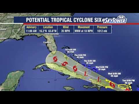
South winds 5 to 15 mph with a few higher gusts west of the Green Mountains. Larry was already a well-structured tropical storm at midday Wednesday, with impressive upper-level outflow and intense showers and thunderstorms spiraling around the low-level center and hints of a large eye already taking shape. The 06Z Wednesday runs of the high-resolution HMON and HWRF models both depict Larry becoming a hurricane by Friday, and the 12Z Wednesday SHIPS statistical model gives Larry a 29% chance of rapid strengthening through Thursday . Given Larry's breakneck growth on satellite and the favorable setting, the National Hurricane Center forecast issued Wednesday morning was on the bullish side, making Larry a hurricane by Thursday and a major category 3 hurricane with 120-mph winds by Saturday. Verizon FiOS dropped the Weather Channel and its sister network Weatherscan from its lineup on March 10, 2015, after the two parties were unable to come to terms on a new carriage agreement. The services have respectively been replaced by the AccuWeather Network and a widget provided by FiOS featuring forecast content provided by WeatherBug.
No public announcement was made regarding the removal until over 12 hours after TWC and Weatherscan were pulled. The Weather Channel offered a less expensive deal to Verizon FiOS, which rejected the offer. Verizon cited the Weather Channel's frequent use of scare tactics, naming of winter storms and the wide availability of the internet and mobile apps for consumers to access weather content any time of day as the reason for dropping TWC and its services. It is unknown if Frontier FiOS customers in clusters formerly served by Verizon are affected, including the recently acquired clusters from California, Texas, and Florida.
The Weather Channel also broadcast original weather-related documentary/entertainment series and specials. These programs ran throughout the rest of the schedule. TWC normally utilizes a different music theme for these events, dubbed "Storm Alert Mode", used for both WCL and LOT8's. Offers of several subscription tiers are made available for users in other to enjoy this app to optimal satisfaction.
Users with iOS version can opt for the Tier 3 subscription plan with a price of $24.99 per annum. It comes with notification of a report on weather conditions relating to storms, lightning strikes, snow, and rain. For the Tier 2 subscription, $9.99 per annum is all you need to keep enjoying this app. This tier allows users to create their custom reminders in which can be triggered by weather conditions. The last subscription plan, Tier 1, offers notification of very critical weather conditions.


